Arctic Ocean
Population
N/A
Area
15,558,000 km²
GDP
N/A
GDP Per Capita
N/A
Background
Geography14
Location
body of water between Europe, Asia, and North America, mostly north of the Arctic Circle
Geographic coordinates
90 00 N, 0 00 E
Map references
Arctic Region
Area
Area - comparative
slightly less than 1.5 times the size of the US
Coastline
45,389 km
Climate
polar climate characterized by persistent cold and relatively narrow annual temperature range; winters characterized by continuous darkness, cold and stable weather conditions, and clear skies; summers characterized by continuous daylight, damp and foggy weather, and weak cyclones with rain or snow
Ocean volume
percent of World Ocean total volume: 1.4%
Major ocean currents
two major, slow-moving, wind-driven currents (drift streams) dominate: a clockwise drift pattern in the Beaufort Gyre in the western part of the Arctic Ocean and a nearly straight line Transpolar Drift Stream that moves eastward across the ocean from the New Siberian Islands (Russia) to the Fram Strait (between Greenland and Svalbard); sea ice that lies close to the center of the gyre can complete a 360 degree circle in about 2 years, while ice on the gyre periphery will complete the same circle in about 7-8 years; sea ice in the Transpolar Drift crosses the ocean in about 3 years
Bathymetry
continental shelf
the following are examples of continental-shelf features in the Arctic Ocean (see Figure 2):
Barents Shelf
Beaufort Shelf
Davis Sill
Chukchi Shelf
East Siberian Shelf
Kara Shelf
Laptev Shelf
Lincoln Shelf
continental slope
Litke Trough
Novaya Zemlya Trough
Svyataya Anna Trough (Saint Anna Trough)
Voronin Trough
abyssal plains
Baffin Basin
Canada Basin
Fram/Amundsen Basin
Greenland Abyssal Plain
Iceland Basin
Makarov Basin
Molloy Deep (deepest point in the Arctic Ocean)
Nansen Basin
Norwegian Basin
mid-ocean ridge
Gakkel Ridge
Mohns Ridge
undersea terrain features
Lomonosov Ridge
Gakkel Ridge
Alpha Ridge
Mendeleev Rise
Chukchi Plateau
ocean trenches
atolls
Elevation
lowest point: Molloy Deep -5,577 m
mean depth: -1,205 m
ocean zones: the ocean is divided into three zones based on depth and light level; sunlight entering the water may travel about 1,000 m into the oceans under the right conditions, but there is rarely any significant light below 200 m
euphotic zone: the upper 200 m (656 ft) is also called "sunlight" zone; only a small amount of light penetrates beyond this depth
dysphotic zone: between 200 m (656 ft) and 1,000 m (3,280 ft), and also called the twilight zone; the intensity of light rapidly dissipates as depth increases, and photosynthesis is no longer possible
aphotic zone: below 1,000 m (3,280 ft) and also called the midnight zone; sunlight does not penetrate to these depths
Natural resources
sand and gravel aggregates, placer deposits, polymetallic nodules, oil and gas fields, fish, marine mammals (seals and whales)
Natural hazards
ice islands occasionally break away from northern Ellesmere Island; icebergs calved from glaciers in western Greenland and extreme northeastern Canada; permafrost in islands; virtually ice locked from October to June; ships subject to superstructure icing from October to May
Geography - note
major chokepoint is the southern Chukchi Sea (northern access to the Pacific Ocean via the Bering Strait); strategic location between North America and Russia; shortest marine link between the extremes of eastern and western Russia; floating research stations operated by the US and Russia; maximum snow cover in March or April about 20 to 50 centimeters over the frozen ocean; snow cover lasts about 10 months
Government1
Country name
Transportation1
Transportation - note
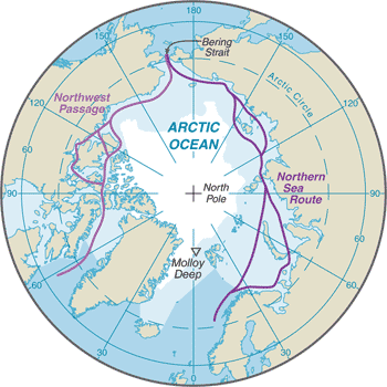
sparse network of air, ocean, river, and land routes; the Northwest Passage (North America) and Northern Sea Route (Eurasia) are important seasonal waterways
Compare Arctic Ocean
See how Arctic Ocean compares to other countries side by side.
Compare Countries