
Ashmore and Cartier Islands
Territory of Ashmore and Cartier Islands
Population
N/A
Area
5 km²
GDP
N/A
GDP Per Capita
N/A
Quick Facts
Currency
$United States dollar(USD)
Calling Code
+1684
Timezone
UTC-11:00
Languages
English, Samoan
Driving Side
right
Demonym
American Samoan
Background
Indonesian fishermen have long fished in the area around Ashmore Reef and Cartier Island. British explorers were the first Europeans to see Cartier Island and Ashmore Reef in 1800 and 1811, respectively. American whalers frequently sailed by the islands in the 1850s and later settled to mine the phosphate deposits on Ashmore Reef, which were exhausted by 1891. The UK disputed US access to Ashmore Reef and formally annexed it in 1878. Cartier Island was annexed in 1909. In 1931, the UK transferred the islands to Australia, which accepted them in 1934 as part of Western Australia. In 1938, Australia transferred governance to the Northern Territory. During World War II, Cartier Island was used as a bombing range. In 1978, governance of Ashmore and Cartier Islands was moved to the federal government. Ashmore Reef and Cartier Island became marine reserves in 1983 and 2000 respectively.
In 1974, Australia and Indonesia signed a memorandum of understanding (MOU) to allow Indonesian fishermen to continue fishing around the islands. The MOU also allows Indonesian fishermen to visit the graves of past fishermen, replenish their fresh water, and shelter in the West Island Lagoon of Ashmore Reef. In the 1990s, Indonesia challenged Australia’s claim to the islands, which was settled in a maritime boundary treaty in 1997. The islands were a popular first point of contact for migrants and refugees seeking to enter Australia, so in 2001, Australia declared the islands to be outside the Australian migration zone.
Historical Trends
GDP (USD)
↑76.7% since 2006Population
↓17.0% since 2006Life Expectancy at Birth
Latest: 72.9 yearsData source: World Bank Open Data
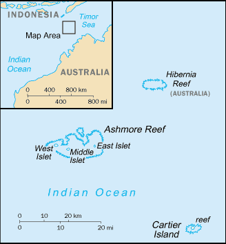
Geography15
Location
Southeastern Asia, islands in the Indian Ocean, midway between northwestern Australia and Timor island; Ashmore Reef is 840 km west of Darwin and 610 km north of Broome; Cartier Islet is 70 km east of Ashmore Reef
Geographic coordinates
Map references
Southeast Asia
Area
land: 5 sq km
water: 0 sq km
Area - comparative
about eight times the size of the National Mall in Washington, D.C.
Land boundaries
Coastline
74.1 km
Maritime claims
contiguous zone: 24 nm
continental shelf: 200-m depth or to the depth of exploitation
exclusive fishing zone: 200 nm
Climate
tropical
Terrain
low with sand and coral
Elevation
lowest point: Indian Ocean 0 m
Natural resources
fish
Land use
Natural hazards
surrounded by shoals and reefs that can pose maritime hazards
Geography - note
Ashmore Reef National Nature Reserve established in 1983; Cartier Island Marine Reserve established in 2000
People & Society1
Population
Government7
Country name
conventional short form: Ashmore and Cartier Islands
etymology: named after British Captain Samuel ASHMORE, who first sighted the island in 1811, and after the ship Cartier, from which the second island was discovered in 1800
Dependency status
territory of Australia; administered from Canberra by the Department of Regional Australia, Local Government, Arts and Sport
Legal system
the laws of the Commonwealth of Australia and the laws of the Northern Territory of Australia, where applicable, apply
Citizenship
see Australia
Diplomatic representation in the US
none (territory of Australia)
Diplomatic representation from the US
Flag
the flag of Australia is used
Military & Security1
Military - note
defense is the responsibility of Australia
Compare Ashmore and Cartier Islands
See how Ashmore and Cartier Islands compares to other countries side by side.
Compare Countries