Atlantic Ocean
Population
N/A
Area
85,133,000 km²
GDP
N/A
GDP Per Capita
N/A
Background
Geography14
Location
body of water between Africa, Europe, the Arctic Ocean, the Americas, and the Southern Ocean
Geographic coordinates
0 00 N, 25 00 W
Map references
Map of the world oceans
Area
Area - comparative
about 7.5 times the size of the US
Coastline
111,866 km
Climate
tropical cyclones (hurricanes) develop off the coast of Africa near Cabo Verde and move westward into the Caribbean Sea; hurricanes can occur from May to December but are most frequent from August to November
Ocean volume
percent of World Ocean total volume: 23.3%
Major ocean currents
clockwise North Atlantic Gyre consists of the northward flowing, warm Gulf Stream in the west, the eastward flowing North Atlantic Current in the north, the southward flowing cold Canary Current in the east, and the westward flowing North Equatorial Current in the south; the counterclockwise South Atlantic Gyre composed of the southward flowing warm Brazil Current in the west, the eastward flowing South Atlantic Current in the south, the northward flowing cold Benguela Current in the east, and the westward flowing South Equatorial Current in the north
Bathymetry
continental shelf
the following are examples of features on the continental shelf of the Atlantic Ocean:
Blake Plateau (Figure 5)
Celtic Shelf (Figure 2)
Dogger Bank (Figure 2)
Flemish Cap (Figure 2)
Falkland Plateau (Figure 3)
Grand Banks of Newfoundland (Figure 2)
Great Bahama Bank (Figure 5)
Little Bahama Bank (Figure 5)
Tunisian Plateau (Figure 4)
Yucatán Shelf (Figure 5)
continental slope
Amazon Cone (Figure 3)
Congo Fan (Figure 3)
Hudson Canyon (Figure 5)
Mississippi Fan (Figure 5)
abyssal plains
Angola Basin (Figure 3)
Agulhas Basin (Figure 3)
Argentine Basin (Figure 3)
Brazil Basin (Figure 3)
Canary Basin (Figure 2)
Cape Basin (Figure 3)
Colombia Basin (Figure 2)
Labrador Basin (Figure 2)
Mexico Basin (Figure 2)
Newfoundland Basin (Figure 2)
North American Basin (Figure 2)
Venezuela Basin (Figure 2)
West European Basin (Figure 2)
mid-ocean ridge
the following are examples of mid-ocean ridges on the floor of the Atlantic Ocean:
East Mediterranean Ridge (Figure 4)
Mid-Atlantic Ridge (Figures 2, 3)
Reykjanes Ridge (Figure 2)
undersea terrain features
Bermuda Rise (Figure 2)
Cape Verde Plateau (Figure 2)
New England Seamounts (Figure 2)
Rio Grande Plateau (Figure 3)
Rockall Plateau (Figure 2)
ocean trenches
Cayman Trench (Caribbean Sea) (Figure 2)
Hellenic Trench (Mediterranean Sea) (Figure 4)
Puerto Rico Trench (Figure 2) - deepest point in the Atlantic
South Sandwich Trench (South Atlantic) (Figure 3)
atolls
Elevation
lowest point: Puerto Rico Trench -8,605 m
mean depth: -3,646 m
ocean zones: the ocean is divided into three zones based on depth and light level; sunlight entering the water may travel about 1,000 m into the oceans under the right conditions, but there is rarely any significant light below 200 m
euphotic zone: the upper 200 m (656 ft) is also called "sunlight" zone; only a small amount of light penetrates beyond this depth
dysphotic zone: between 200 m (656 ft) and 1,000 m (3,280 ft), and also called the twilight zone; the intensity of light rapidly dissipates as depth increases, and photosynthesis is no longer possible
aphotic zone: below 1,000 m (3,280 ft) and also called the midnight zone; sunlight does not penetrate to these depths
Natural resources
oil and gas fields, fish, marine mammals (seals and whales), sand and gravel aggregates, placer deposits, polymetallic nodules, precious stones
Natural hazards
icebergs common in Davis Strait, Denmark Strait, and the northwestern Atlantic Ocean from February to August and have been spotted as far south as Bermuda and the Madeira Islands; ships subject to superstructure icing in extreme northern Atlantic from October to May; persistent fog can be a maritime hazard from May to September; hurricanes (May to December)
Geography - note
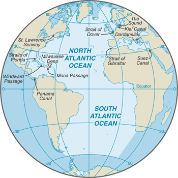
major chokepoints include the Dardanelles, Strait of Gibraltar, access to the Panama and Suez Canals; strategic straits include the Strait of Dover, Straits of Florida, Mona Passage, The Sound (Oresund), and Windward Passage; the equator divides the Atlantic Ocean into the North Atlantic Ocean and South Atlantic Ocean
Government1
Country name
Transportation1
Transportation - note
Kiel Canal and Saint Lawrence Seaway are two important waterways; significant domestic commercial and recreational use of Intracoastal Waterway on central and south Atlantic seaboard and Gulf of America coast of US
Compare Atlantic Ocean
See how Atlantic Ocean compares to other countries side by side.
Compare Countries