
Guam
Population
169.5K
Area
544 km²
GDP
$6.91B
GDP Per Capita
$35,600
Pop. Density
312/km²
Quick Facts
Currency
$United States dollar(USD)
Calling Code
+1671
Timezone
UTC+10:00
Languages
Chamorro, English, Spanish
Driving Side
right
Demonym
Guamanian
Background
Guam was settled by Austronesian people around 1500 B.C. These people became the indigenous Chamorro and were influenced by later migrations, including the Micronesians in the first millennium A.D., and island Southeast Asians around 900. Society was stratified, with higher classes living along the coast and lower classes living inland. Spanish explorer Ferdinand MAGELLAN was the first European to see Guam in 1521, and Spain claimed the island in 1565 because it served as a refueling stop for ships between Mexico and the Philippines. Spain formally colonized Guam in 1668. Spain’s brutal repression of the Chamorro, along with new diseases and intermittent warfare, reduced the indigenous population from more than 100,000 to less than 5,000 by the 1700s. Spain tried to repopulate the island by forcing people from nearby islands to settle on Guam and preventing them from escaping.
Guam became a hub for whalers and traders in the western Pacific in the early 1800s. During the 1898 Spanish-American War, the US Navy occupied Guam and set up a military administration. The US Navy opposed local control of government despite repeated petitions from the Chamorro. Japan invaded Guam in 1941 and instituted a repressive regime. During the US recapture of Guam in 1944, the island’s two largest villages were destroyed. After World War II, political pressure from local Chamorro leaders led to Guam being established as an unincorporated organized US territory in 1950, with US citizenship granted to all Chamorro. In a referendum in 1982, more than 75% of voters chose closer relations with the US over independence, although no change in status was made because of disagreements on the future right of Chamorro self-determination. The US military holds about 29% of Guam’s land and stations several thousand troops on the island. The installations are some of the most strategically important US bases in the Pacific; they also constitute the island’s most important source of income and economic stability.
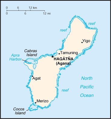
Geography17
Location
Oceania, island in the North Pacific Ocean, about three-quarters of the way from Hawaii to the Philippines
Geographic coordinates
13 28 N, 144 47 E
Map references
Oceania
Area
land: 544 sq km
water: 0 sq km
Area - comparative
three times the size of Washington, D.C.
Land boundaries
Coastline
125.5 km
Maritime claims
exclusive economic zone: 200 nm
Climate
tropical marine; generally warm and humid, moderated by northeast trade winds; dry season (January to June), rainy season (July to December); little seasonal temperature variation
Terrain
volcanic origin, surrounded by coral reefs; relatively flat coralline limestone plateau (source of most fresh water), with steep coastal cliffs and narrow coastal plains in north, low hills in center, mountains in south
Elevation
lowest point: Pacific Ocean 0 m
Natural resources
aquatic wildlife (supporting tourism), fishing (largely undeveloped)
Land use
agricultural land
agricultural land: arable land
agricultural land: permanent crops
agricultural land: permanent pasture
forest
other
Irrigated land
2 sq km (2012)
Population distribution
no large cities exist on the island; large villages (municipalities) attract much of the population; the largest of these is Dededo
Natural hazards
frequent squalls during rainy season; relatively rare but potentially destructive typhoons (June to December)
Geography - note
largest and southernmost island in the Mariana Islands archipelago and the largest island in Micronesia; strategic location in western North Pacific Ocean
People & Society23
Population
male: 87,345
female: 82,187
Nationality
adjective: Guamanian
Ethnic groups
Native Hawaiian and other Pacific Islander 46.1% (Chamorro 32.8%, Chuukese 6.7%, Palauan 1.4%, Pohnpeian 1.4%, Yapese 1%, other Native Hawaiian and other Pacific Islander 2.8%), Asian 35.5% (Filipino 29.1%, Korean 2.2%, Japanese 1.4%, Chinese (except Taiwanese) 1.3%, other Asian 1.5%), White 6.8%, African descent or African-American 0.9%, Indigenous 0.1%, other 0.6%, mixed 10% (2020 est.)
Languages
English 43.3%, Filipino 24.9%, Chamorro 16%, other Pacific Island languages 9.4%, Asian languages 6.5% (2020 est.)
Religions
Christian (predominantly Roman Catholic) 94.2%, folk religions 1.5%, Buddhist 1.1%, other 1.6%, unaffiliated 1.7% (2020 est.)
Age structure
15-64 years: 62.7% (male 55,591/female 50,741)
65 years and over: 10.9% (2024 est.) (male 8,615/female 9,814)
Dependency ratios
youth dependency ratio: 42.1 (2024 est.)
elderly dependency ratio: 17.3 (2024 est.)
potential support ratio: 5.8 (2024 est.)
Median age
male: 29.6 years
female: 31.1 years
Population growth rate
0.08% (2025 est.)
Birth rate
17.9 births/1,000 population (2025 est.)
Death rate
6.18 deaths/1,000 population (2025 est.)
Net migration rate
-10.92 migrant(s)/1,000 population (2025 est.)
Population distribution
no large cities exist on the island; large villages (municipalities) attract much of the population; the largest of these is Dededo
Urbanization
rate of urbanization: 0.84% annual rate of change (2020-25 est.)
Major urban areas - population
147,000 HAGATNA (capital) (2018)
Sex ratio
0-14 years: 1.07 male(s)/female
15-64 years: 1.1 male(s)/female
65 years and over: 0.88 male(s)/female
total population: 1.06 male(s)/female (2024 est.)
Infant mortality rate
male: 11 deaths/1,000 live births
female: 10.9 deaths/1,000 live births
Life expectancy at birth
male: 75.6 years
female: 80.5 years
Total fertility rate
2.7 children born/woman (2025 est.)
Gross reproduction rate
1.31 (2025 est.)
Drinking water source
unimproved: total: total: 0.3% of population (2022 est.)
Sanitation facility access
unimproved: total: total: 0.8% of population (2022 est.)
Currently married women (ages 15-49)
40.4% (2020 est.)
Government21
Country name
conventional long form
conventional short form
local long form
local short form
abbreviation
etymology
Government type
unincorporated organized territory of the US with local self-government; republican form of territorial government with separate executive, legislative, and judicial branches
Dependency status
unincorporated, organized territory of the US, with policy relations between Guam and the Federal government under the jurisdiction of the Office of Insular Affairs, US Department of the Interior
Capital
geographic coordinates: 13 28 N, 144 44 E
time difference: UTC+10 (15 hours ahead of Washington, DC, during Standard Time)
etymology: the name Hagatna is derived from the Chamorro word haga, meaning "life's blood" and referring to the town's role as the center of government for the island
Legal system
common law modeled on US system; US federal laws apply
Constitution
Citizenship
see United States
Suffrage
Executive branch
chief of state
head of government
cabinet
election/appointment process
most recent election date
election results
2022: Lourdes LEON GUERRERO reelected governor; percent of vote - Lourdes LEON GUERRERO (Democratic Party) 55%, Felix CAMACHO (Republican Party) 44%; Josh TENORIO (Democratic Party) elected lieutenant governor
2018: Lourdes LEON GUERRERO elected governor; percent of vote - Lourdes LEON GUERRERO (Democratic Party) 50.7%, Ray TENORIO (Republican Party) 26.4%; Josh TENORIO (Democratic Party) elected lieutenant governor
expected date of next election
Legislative branch
legislature name
legislative structure
number of seats
electoral system
scope of elections
term in office
most recent election date
parties elected and seats per party
percentage of women in chamber
expected date of next election
Judicial branch
judge selection and term of office: justices appointed by the governor and confirmed by the Guam legislature; justices appointed for life but subject to retention election every 10 years
subordinate courts: Superior Court of Guam (includes several divisions); US Federal District Court for the District of Guam (a US territorial court; appeals beyond this court are heard before the US Court of Appeals for the Ninth Circuit)
Political parties
Republican Party
Diplomatic representation in the US
none (territory of the US)
Diplomatic representation from the US
International organization participation
AOSIS (observer), IOC, PIF (observer), SPC, UPU
Independence
none (territory of the US)
National holiday
Discovery Day (or Magellan Day), first Monday in March (1521)
Flag
meaning: blue stands for the sea and red for the blood shed in the fight against oppression; the central emblem is shaped like a Chamorro sling stone (a weapon for defense or hunting)
National symbol(s)
coconut tree
National color(s)
deep blue, red
National anthem(s)
lyrics/music: Francis Scott KEY/John Stafford SMITH
history: official anthem, as a US territory; played before "Stand, Ye Guamanians"
Economy19
Economic overview
small Pacific island US territorial economy; upper income, tourism-based economy; hard-hit by COVID-19 disruptions; relaunched many industries via vaccination tourism; domestic economy relies on multiple military bases; environmentally fragile economy
Real GDP growth rate
Real GDP growth rate 2021: 2.1% (2021 est.)
Real GDP growth rate 2020: -10.5% (2020 est.)
Real GDP per capita
Real GDP per capita 2015: $35,200 (2015 est.)
Real GDP per capita 2014: $34,400 (2014 est.)
GDP (official exchange rate)
Agricultural products
fruits, copra, vegetables; eggs, pork, poultry, beef
Industries
national defense, tourism, construction, transshipment services, concrete products, printing and publishing, food processing, textiles
Labor force
Unemployment rate
Unemployment rate 2023: 5.4% (2023 est.)
Unemployment rate 2022: 5.5% (2022 est.)
Youth unemployment rate (ages 15-24)
male: 13.3% (2024 est.)
female: 14.1% (2024 est.)
Average household expenditures
on alcohol and tobacco: 1.3% of household expenditures (2021 est.)
Budget
expenditures: $1.299 billion (2016 est.)
Public debt
Exports
Exports 2021: $193 million (2021 est.)
Exports 2020: $379 million (2020 est.)
Exports - partners
Exports - commodities
Imports
Imports 2021: $3.662 billion (2021 est.)
Imports 2020: $3.388 billion (2020 est.)
Imports - partners
Imports - commodities
Exchange rates
the US dollar is used
Energy5
Electricity access
Electricity
consumption: 1.715 billion kWh (2023 est.)
transmission/distribution losses: 90.023 million kWh (2023 est.)
Electricity generation sources
solar: 7.8% of total installed capacity (2023 est.)
wind: 0.1% of total installed capacity (2023 est.)
Petroleum
Energy consumption per capita
Communications6
Telephones - fixed lines
subscriptions per 100 inhabitants: 43 (2022 est.)
Telephones - mobile cellular
subscriptions per 100 inhabitants: 62 (2009 est.)
Broadcast media
about a dozen TV channels, including digital; multi-channel cable TV services are available; roughly 20 radio stations
Internet country code
.gu
Internet users
Broadband - fixed subscriptions
subscriptions per 100 inhabitants: 2 (2022 est.)
Transportation5
Civil aircraft registration country code prefix
N
Airports
3 (2025)
Heliports
2 (2025)
Merchant marine
by type: other 3
Ports
total ports
large
medium
small
very small
ports with oil terminals
key ports
Military & Security2
Military and security forces
Military - note
the US military maintains thousands of active-duty uniformed personnel and several bases and installations on the island