South Georgia and South Sandwich Islands
South Georgia and the South Sandwich Islands
Population
N/A
Area
3,903 km²
GDP
N/A
GDP Per Capita
N/A
Quick Facts
Currency
£British pound(GBP)
Calling Code
+500
Timezone
UTC-02:00
Languages
English
Driving Side
right
Demonym
South Georgian South Sandwich Islander
Background
Geography16
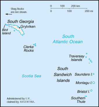
Location
Southern South America, islands in the South Atlantic Ocean, east of the tip of South America
Geographic coordinates
54 30 S, 37 00 W
Map references
Antarctic Region
Area
land: 3,903 sq km
water: 0 sq km
Area - comparative
slightly larger than Rhode Island
Land boundaries
Coastline
NA
Maritime claims
exclusive fishing zone: 200 nm
Climate
variable, with mostly westerly winds throughout the year interspersed with periods of calm; nearly all precipitation falls as snow
Terrain
most of the islands are rugged and mountainous rising steeply from the sea; South Georgia is largely barren with steep, glacier-covered mountains; the South Sandwich Islands are of volcanic origin with some active volcanoes
Elevation
lowest point: Atlantic Ocean 0 m
Natural resources
fish
Land use
Irrigated land
0 sq km (2022)
Natural hazards
the South Sandwich Islands have prevailing weather conditions that generally make them difficult to approach by ship; they are also subject to active volcanism
Geography - note
the north coast of South Georgia has several large bays, which provide good anchorage
People & Society1
Population
Government7
Country name
conventional short form: South Georgia and South Sandwich Islands
abbreviation: SGSSI
etymology: Captain James COOK originally named it "the Isle of Georgia" in 1775 in honor of British King GEORGE III; the word "South" was later added to distinguish these islands from the other Sandwich Islands, now known as the Hawaiian Islands
Dependency status
overseas territory of the UK, also claimed by Argentina; administered from the Falkland Islands by a commissioner, who is concurrently governor of the Falkland Islands, representing the British monarch
Legal system
the laws of the UK apply
Diplomatic representation in the US
none (administered by the UK, claimed by Argentina)
Diplomatic representation from the US
none (administered by the UK, claimed by Argentina)
International organization participation
UPU
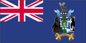
Flag
meaning: the lion represents the UK and discovery; the seal, penguin, and reindeer are native to the islands
Transportation2
Heliports
1 (2025)
Ports
total ports
large
medium
small
very small
ports with oil terminals
key ports
Military & Security1
Military - note
defense is the responsibility of the UK
Compare South Georgia and South Sandwich Islands
See how South Georgia and South Sandwich Islands compares to other countries side by side.
Compare Countries