Southern Ocean
Population
N/A
Area
21,960,000 km²
GDP
N/A
GDP Per Capita
N/A
Background
Geography14
Location
body of water between 60 degrees south latitude and Antarctica
Geographic coordinates
60 00 S, 90 00 E (nominally), but the Southern Ocean has the unique distinction of being a large circumpolar body of water totally encircling the continent of Antarctica; this ring of water lies between 60 degrees south latitude and the coast of Antarctica and encompasses 360 degrees of longitude
Map references
Antarctic Region
Area
Area - comparative
slightly more than twice the size of the US
Coastline
17,968 km
Climate
sea temperatures vary from about 10 degrees Celsius to -2 degrees Celsius; cyclonic storms travel eastward around the continent and frequently are intense because of the temperature contrast between ice and open ocean; the ocean area from about latitude 40 south to the Antarctic Circle has the strongest average winds found anywhere on Earth; in winter the ocean freezes outward to 65 degrees south latitude in the Pacific sector and 55 degrees south latitude in the Atlantic sector, lowering surface temperatures well below 0 degrees Celsius; at some coastal points intense persistent drainage winds from the interior keep the shoreline ice-free throughout the winter
Ocean volume
percent of World Ocean total volume: 5.4%
Major ocean currents
the cold, clockwise-flowing Antarctic Circumpolar Current (West Wind Drift; 21,000 km long) moves perpetually eastward around the continent and is the world's largest and strongest ocean current, transporting 130 million cubic meters of water per second - 100 times the flow of all the world's rivers; it is also the only current that flows all the way around the planet and connects the Atlantic, Pacific, and Indian Ocean basins; the cold Antarctic Coastal Current (East Wind Drift) is the southernmost current in the world, flowing westward and parallel to the Antarctic coastline
Bathymetry
continental shelf
Astrid Ridge (see also Figure 4)
Belgrano Bank
Gunnerus Ridge (see also Figure 4)
Hayes Bank
Iselin Bank
continental slope
Amery Basin (Figure 4)
Filchner Trough
Hillary Canyon
Pobeda Canyon (Figure 3)
abyssal plains
Amundsen (Abyssal) Plain
Enderby (Abyssal) Plain
South Indian/Australian-Antarctic Basin
Southeast Pacific/Bellinghausen Basin
Weddell (Abyssal) Plain
mid-ocean ridge
Pacific-Antarctic Ridge (Figure 3)
undersea terrain features
Akopov Seamounts (Figure 3)
De Gerlache Seamounts (see also Figure 3, 4)
Endurance Ridge (Figure 4)
Marie Byrd Seamount (see also Figure 3)
Maud Rise (see also Figure 4)
Scott Seamounts (see also Figure 3)
ocean trenches
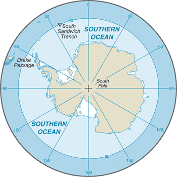
South Sandwich Trench (Figure 4; the deepest location in the Southern Ocean)
atolls
Elevation
lowest point: southern end of the South Sandwich Trench -7,434 m unnamed deep
mean depth: -3,270 m
ocean zones: the ocean is divided into three zones based on depth and light level; sunlight entering the water may travel about 1,000 m into the oceans under the right conditions, but there is rarely any significant light below 200 m
euphotic zone: the upper 200 m (656 ft) is also called "sunlight" zone; only a small amount of light penetrates beyond this depth
dysphotic zone: between 200 m (656 ft) and 1,000 m (3,280 ft), and also called the twilight zone; the intensity of light rapidly dissipates as depth increases, and photosynthesis is no longer possible
aphotic zone: below 1,000 m (3,280 ft) and also called the midnight zone; sunlight does not penetrate to these depths
Natural resources
probable large oil and gas fields on the continental margin; manganese nodules, possible placer deposits, sand and gravel, fresh water as icebergs; krill, fish
Natural hazards
huge icebergs with drafts up to several hundred meters; smaller bergs and iceberg fragments; sea ice (generally 0.5 to 1 m thick) with sometimes dynamic short-term variations and with large annual and interannual variations; deep continental shelf floored by glacial deposits varying widely over short distances; high winds and large waves much of the year; ship icing, especially May-October; most of region is remote from sources of search and rescue
Geography - note
the major chokepoint is the Drake Passage between South America and Antarctica; the Polar Front (Antarctic Convergence) is the best natural definition of the northern extent of the Southern Ocean; it is a distinct region at the middle of the Antarctic Circumpolar Current that separates the cold polar surface waters to the south from the warmer waters to the north; the Front and the Current extend entirely around Antarctica, reaching south of 60 degrees south near New Zealand and near 48 degrees south in the far South Atlantic, coinciding with the path of the maximum westerly winds
Government1
Country name
Transportation1
Transportation - note
Drake Passage offers alternative to transit through the Panama Canal
Compare Southern Ocean
See how Southern Ocean compares to other countries side by side.
Compare Countries